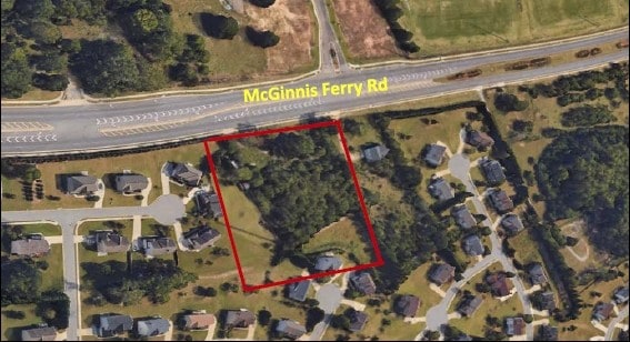
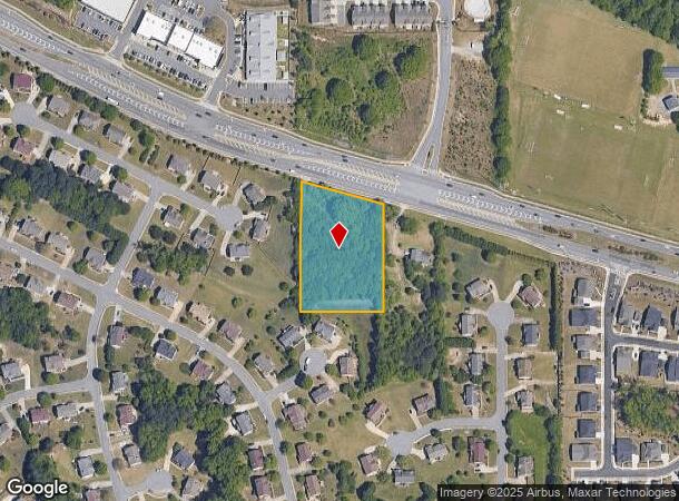
Property Record
8101 Mcginnis Ferry Rd, Suwanee, GA 30024
NEARBY LISTINGS FOR SALE OR LEASE
Property Detail
8101 Mcginnis Ferry Rd
Atlanta-Sandy Springs-Roswell, GA
Not Shown
11-1290-0502-010-6
VACANT LOT10/20 NO WORK
Residentialacreage
Fulton
X
Georgia
13121C0111G
10
2024
1.70 AC
2025
N Fulton/Forsyth County
011635
Atlanta
DEMOGRAPHICS near 8101 Mcginnis Ferry Rd
1 Mile
3 Mile
5 Mile
2024 Total Population
4,818
58,301
178,926
2029 Population
5,114
62,166
190,056
Pop Growth 2024-2029
+ 6.14%
+ 6.63%
+ 6.22%
Average Age
38
39
39
2024 Total Households
1,409
19,440
60,390
HH Growth 2024-2029
+ 6.25%
+ 6.66%
+ 6.13%
Median Household Inc
$136,672
$132,499
$120,406
Avg Household Size
3.30
3.00
2.90
2024 Avg HH Vehicles
2.00
2.00
2.00
Median Home Value
$479,436
$448,884
$441,784
Median Year Built
2003
1999
1997
Nearby Places
Map Layers
Map Styles
 Street
 Aerial
- Restaurants
- Banks
- Shops
- Fitness
- Groceries
SALE & LEASE HISTORY
LISTING DATE
SALE/LEASE

Oct 12, 2017
For Sale
Nearby Properties
Address
Land Use
TOTAL SIZE
Lot Size
Zoning
Address
Land Use
TOTAL SIZE
Lot Size
Zoning
509,302 SF
55.13 AC
RM8
Address
Land Use
TOTAL SIZE
Lot Size
Zoning
534,578 SF
44.21 AC
RM8
Address
Land Use
TOTAL SIZE
Lot Size
Zoning
393,939 SF
42.21 AC
RM8
Address
Land Use
TOTAL SIZE
Lot Size
Zoning
359,241 SF
21.02 AC
PMUD
Address
Land Use
TOTAL SIZE
Lot Size
Zoning
559,910 SF
74.65 AC
Address
Land Use
TOTAL SIZE
Lot Size
Zoning
334,841 SF
28.14 AC
RM13
Address
Land Use
TOTAL SIZE
Lot Size
Zoning
299,952 SF
23.49 AC
MIAC
Address
Land Use
TOTAL SIZE
Lot Size
Zoning
372,904 SF
11.64 AC
PUD
Address
Land Use
TOTAL SIZE
Lot Size
Zoning
253,169 SF
8.74 AC
RM24
Address
Land Use
TOTAL SIZE
Lot Size
Zoning
234,420 SF
10.35 AC
PMUD
Address
Land Use
TOTAL SIZE
Lot Size
Zoning
370,414 SF
14.34 AC
PMUD
Address
Land Use
TOTAL SIZE
Lot Size
Zoning
185,524 SF
12.61 AC
M1
Address
Land Use
TOTAL SIZE
Lot Size
Zoning
201,040 SF
26.40 AC
R100
Address
Land Use
TOTAL SIZE
Lot Size
Zoning
1,682 SF
303.40 AC
A1
Address
Land Use
TOTAL SIZE
Lot Size
Zoning
102,784 SF
9.16 AC
MIAC
Address
Land Use
TOTAL SIZE
Lot Size
Zoning
196,380 SF
15.97 AC
M1
Address
Land Use
TOTAL SIZE
Lot Size
Zoning
109,568 SF
2.85 AC
C2
Address
Land Use
TOTAL SIZE
Lot Size
Zoning
43,427 SF
31.12 AC
M1
Address
Land Use
TOTAL SIZE
Lot Size
Zoning
150,402 SF
14.12 AC
OI
Address
Land Use
TOTAL SIZE
Lot Size
Zoning
70,887 SF
6.83 AC
OI
Address
Land Use
TOTAL SIZE
Lot Size
Zoning
126,920 SF
12.25 AC
M1
Address
Land Use
TOTAL SIZE
Lot Size
Zoning
131.01 AC
AG1
Address
Land Use
TOTAL SIZE
Lot Size
Zoning
98,633 SF
13.20 AC
MIAC
Address
Land Use
TOTAL SIZE
Lot Size
Zoning
772.94 AC
MINE
Address
Land Use
TOTAL SIZE
Lot Size
Zoning
102,710 SF
26.25 AC
AG1
Address
Land Use
TOTAL SIZE
Lot Size
Zoning
132,795 SF
41.71 AC
Address
Land Use
TOTAL SIZE
Lot Size
Zoning
103,628 SF
7.94 AC
MIAC
Address
Land Use
TOTAL SIZE
Lot Size
Zoning
144,242 SF
11.14 AC
MIAC
Address
Land Use
TOTAL SIZE
Lot Size
Zoning
102,560 SF
7.50 AC
MIAC
Address
Land Use
TOTAL SIZE
Lot Size
Zoning
203,115 SF
16.46 AC
MIAC
The World's #1 Commercial Real Estate Marketplace
Connect with us
© 2025 CoStar Group
The information above has been obtained from sources believed reliable. While we do not doubt its accuracy we have not verified it and make no guarantee, warranty or representation about it. It is your responsibility to independently confirm its accuracy and completeness. Any projections, opinions, assumptions, or estimates used are for example only and do not represent the current or future performance of the property. The value of this transaction to you depends on tax and other factors which should be evaluated by your tax, financial, and legal advisors. You and your advisors should conduct a careful, independent investigation of the property to determine to your satisfaction the suitability of the property for your needs.